Backbone Mountain is a long ridge running nearly 40 miles through Tucker County, West Virginia and Garrett County, Maryland. The mountain's best known feature is probably Hoye Crest, which stands as the highest point in Maryland. US 219 travels near most of the length of the mountain. Travelers along 219 will notice the a long line of wind turbines along much of the ridge. The 311-mile long Allegheny travels over the south end of the ridge.
Even though the weather was hot, the humidity was surprisingly manageable on Saturday, June 21st. With hotter weather coming the next week, I wanted to hit the mountains while the conditions were more tolerable. I made a last minute decision to hike a section of the Allegheny Trail (ALT). I have been on this stretch of the ALT a couple times, once on a mountain bike ride and when I thru hiked the ALT last October.
Just north of the town of Parsons, a nondescript forest service road turns off of US 219. The Allegheny Trail utilizes this section of forest road. This is the base of Backbone Mountain. I parked a couple minutes down the road at a junction and started hiking up the road.
This is FSR 717. The ALT travels along the road for nearly 1.5 miles before turning onto a proper trail. Before following the trail, I continued the last few hundred yards to the end of the road. The Olson Observation Tower stands at crest of the ridge at the end of the road.
The Olson Tower stands near the southern end of Backbone Mountain. The tower is in pretty good shape and you are still able to climb to the top. From the top of the tower, 360-degree views await. The tower sits at over 3,600', just a few feet under the high point of Backbone Mountain. Climbing the tower adds another 100-feet of elevation and takes you above the tree tops. The stairs up the tower are steep and see through. I wouldn't recommend climbing the tower if you fear heights. I saw someone at the top of the tower struggling to descend while looking down.
If you aren't afraid of heights, climb the tower and enjoy the view. You can see the long stretch of Backbone Mountain and its wind turbines. To the east is the plateau of Canaan Mountain. Blackwater Canyon runs south of the tower. The town of Parsons stands out to the southwest. For those that don't want to hike, the tower can be reached by car. FSR 717 is in pretty good shape.
 |
| Olson Observation Tower |
 |
| View from the tower |
 |
| Blackwater Canyon |
 |
| A good look at the flat mountaintops |
 |
| US 219 below the tower |
 |
| Looking west |
After enjoying the view from the tower, I hiked back down the road to the Allegheny Trail. This section of the trail follows the Canyon Rim Trail. The next three miles or so are some of my favorite miles on the Allegheny Trail. Much of the Canyon Rim Trail travels through a mix of rhododendron and mountain laurel. At times the shrubs form a tunnel. Much of the mountain laurel was in bloom as I hiked through. I find hiking through the tunnels quite enjoyable. There are also a couple of vistas over Blackwater Canyon along the trail.
 |
| Into the green tunnel |
 |
| Another vista along the Canyon Rim Trail |
 |
| Dense tunnel of rhododendron |
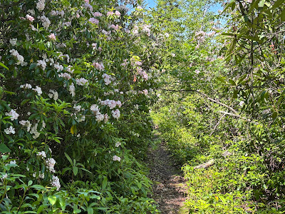 |
| Blooming laurel along the trail |
After three miles on the Canyon Rim Trail, the ALT reaches another junction at FSR 18 by a nice campsite/picnic area. The ALT continues, turning a right at this junction. In less than a 1/4 mile the trail reaches another nice overlook of the canyon.
 |
| Another canyon view |
I enjoyed the view for a few minutes before backtracking a couple hundred feet on the ALT. A sign marks a short side trail to Big Run Falls. The last two times I have been to Big Run Falls, the water levers were quite low and the falls only had a trickle. After a wet six weeks, the falls were flowing pretty heavily. The trail ends at the upper falls. Because water levers were so low the last couple times I didn't bother exploring much. This time the falls roared and I went downstream to check out a couple more falls. The lower sets of falls were just as scenic. Each of the three sets of falls drop at least 20 feet. If you choose to explore the lower sets of falls, use extreme caution, you either have to downclimb small cliffs that can be wet from the creek or bushwhack through dense laurel. Neither option is for the faint of heart.
 |
| The main drop at Big Run Falls |
 |
| Middle falls at Big Run Falls |
 |
| One of the lower falls |
 |
| The full width of the lower falls |
 |
| The middle falls with the upper falls in the background |
 |
| Pink laurel along the falls |
I took in the falls for a while before returning back to the ALT. I took a left and continued on FSR 18. This road serves as a high water alternative to the ALT to avoid Big Run after heavy rains. FSR 18 is somewhat popular with the Jeep crown and its not uncommon to see offroaders along this stretch. Following FSR 18 brought me back to my van in less than two miles, closing off my loop. With my side trips, my hike ran about 7.2 miles. Even though Olson Tower sits at 3,600', the elevation gain is fairly modest on the hike since it never drops below 3,000'. On the Canyon Rim Trail, I only saw one other pair of hikers. You are more likely to encounter people at Olson Tower since you can drive to it. At least a half-dozen vehicles were at the tower. Whether you hike this as an out-and-back to avoid walking on the dirt forest roads or a loop, the Canyon Rim Trail packs in a lot of nice scenery in a relatively easy hike.
Since the hike was fairly easy, I made a last minute decision to do another short hike. About twenty minutes drive to the north along Backbone Mountain is the access to Hoye Crest. Hoye Crest stands as the highest point in Maryland. There's something fun about hitting state high points.
I've read different numbers on the mileage to reach Hoye Crest. The distance from trailhead to summit ranges between 1 and 1.5 miles. No matter how you look at it, it's a short hike that shouldn't take too long. I reached the trailhead just before 5PM.
 |
| Trailhead for Hoye Crest |
The trail starts easy enough on an nice logging road. The road becomes more rocky and pretty muddy at spots as it follows a fence line along private property. The trail veers off the logging road and follows a wide trail. A few junctions are marked with signs or red "HP" painted on trees.
 |
| Marker for the trail |
 |
| Old road to the summit |
The Maryland high point is something of an oddity. Even though it's the high point of Maryland, 95% of the hike travels through West Virginia. Backbone Mountain runs along the state line near hear and the high point of Maryland is just a hump along the ridge very close to the border.
I came to a junction marking the state line. I followed the short side trail to a border monument marking West Virginia on one side, Maryland on the other. It's kind of a novelty standing in two states at once.
 |
| Boundary Monument on Maryland side |
 |
| West Virginia side |
Back to the main trail, I continued a couple more minutes. There are several trails through the area, but the junctions are all marked pointing you in the right direction. The high point is on private land, so follow the signs to stay on track.
 |
| Sign near the high point |
I reached the 3,360' high point of Maryland at Hoye Crest. It took only 23 minutes to reach the Everest of Maryland. A historical marker, small cairn, trail register box, and a couple picnic tables sit a small summit clearing. A small section of cleared trees provides a view to the east. I looked through and signed the register before returning to the trailhead.
 |
| High point register box |
 |
| Historical marker at the high point |
 |
| View at the high point |
On the descent, the trail follows the same path down to the trailhead. When the trail rejoined the logging roads, there are some descent views over a field into West Virginia. These views were better than the narrow view at the summit. I trotted down the trail and reached the trailhead in only 11 minutes. I was back the trailhead around 540PM.
 |
| View during the descent |
 |
The views are better on the way
own than at the top |
 |
| Overgrown logging road |
 |
| One last view during the descent |
If Hoye Crest wasn't the state high point, chances are that nobody would know about it and it would never be visited. I know I wouldn't have hiked it if it wasn't a state high point, but there's an allure to visiting high points. I wouldn't recommend going out of your way to make this hike for the casual hiker. There are much better bangs for you buck if your looking for a scenic hike and you don't hit the trails very often. It wasn't a bad hike either with decent scenery.
I didn't measure the distance myself, but the roundtrip distance is likely only 2-2.5 miles. For a short hike, the trail does gain about 700' in elevation. While not that difficult, the elevation gain left me sweaty with temperatures in the upper 80s.
Neither of these two hikes reach the actual high point of Backbone Mountain. Olson Tower is just a few feet shy of the highest point of Backbone Mountain. The actual highest point of 3,662' sits right along US 219 behind a communication tower near the start of the wind turbines. I don't know for sure, but I think the high point is on private property. A much better view can be seen just a short distance to the south from a roadside picnic area along US 219.
 |
| View from US 219 along Backbone Mountain |
If you enjoyed this post, check out and “LIKE”
Tomcat's Outdoor Adventures where I post photos more often and revisit past adventures.


No comments:
Post a Comment