Nestled between Blue and Tirrell Mountains, Tirrell Pond sits isolated in the Blue Mountain Wild Forest. When I hiked the Northville Placid Trail (NPT) in 2020, the pond stood out as one of my favorite spots along the entire 138-mile trail. I knew I wanted to revisit the pond at some point and hoped to make the trip in winter on skis. As my time living in the Adirondacks winds down the next couple months, I figured I’d better make the trip on skis soon, while the skiable snow still exists.
 |
| Fresh ski tracks along the NPT |
Not much snow fell in February. A few days near 50F didn’t do the snowpack any favors to the already shallow base. Finally, 5” of new snow fell last week to freshen the conditions. With another warm stretch this week, and no real snow forecasted, I hit the trail while the conditions were still decent on February 20th. Just two weeks earlier, I climbed nearby Blue Mountain, which overlooks Tirrell Pond. Looking down on the frozen pond further piqued my interest on making the trip. Even with the new snow, I wasn’t sure the conditions would be great since several rains this winter have left a pretty sparse snowpack for the second half of February.
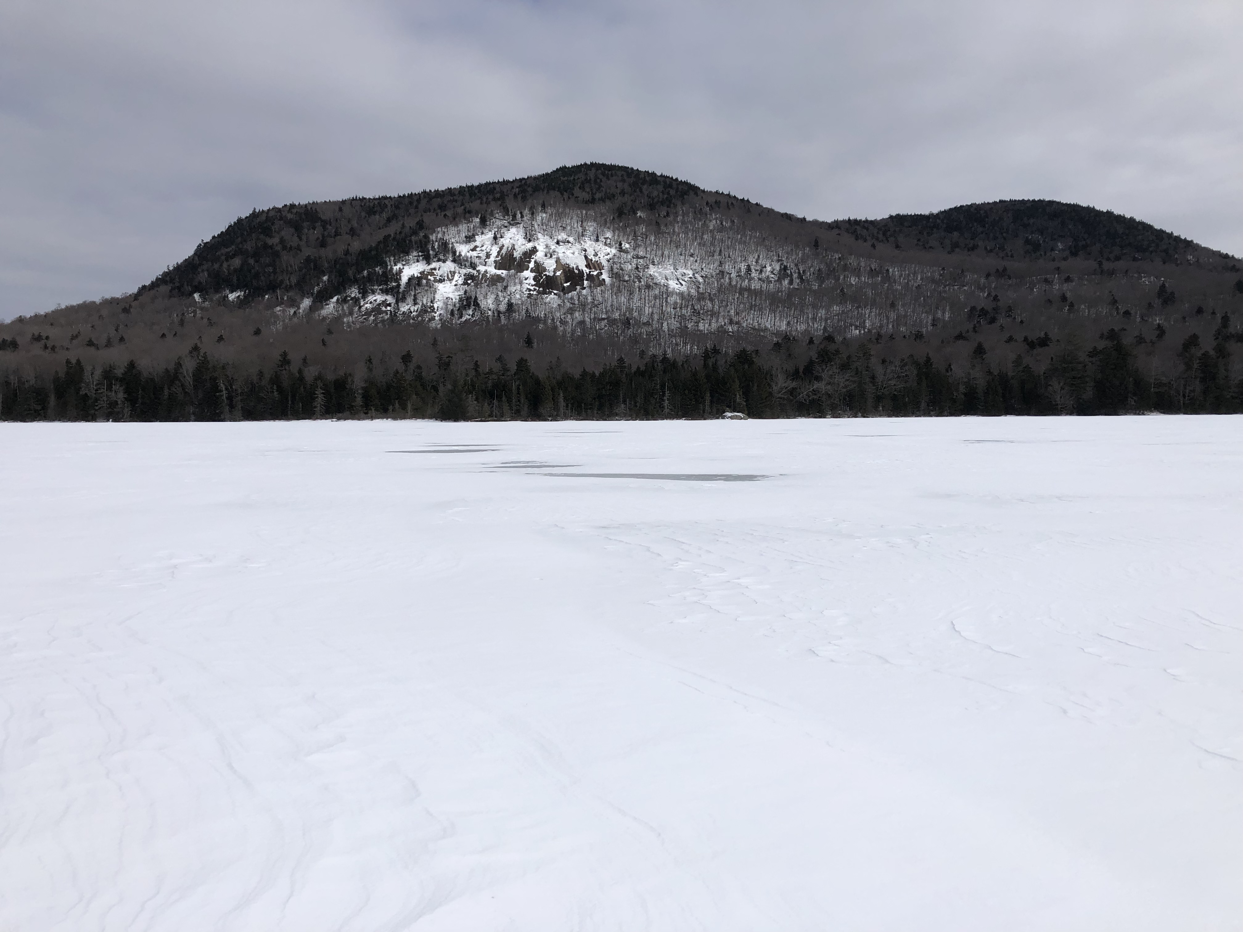
 |
| Tirrell Pond and Mountain from Blue Mountain |
Two trails access Tirrell Pond, one from the Blue Mountain Trailhead and the other via the NPT. I wanted to use the NPT from the south. This trailhead sits just east of Blue Mountain Lake near Durant Lake on Routes 28 and 30.This was also the direction I hiked to Tirrell Pond on my NPT hike.
 |
| Trailhead sign |
I began skiing a little after 9AM. I wasn’t sure how trafficked the trail gets in the winter, but snowshoe tracks and at least one set of skis packed the trail at the start. With the temperature only in the teens, the packed snowshoe track skied quite fast.
 |
The first short stretch looked sketchy
with minimal snow |
 |
| Snowshoe tracks from the previous days |
After about 3/4 of a mile the snowshoe tracks stopped at a meadow and turned around. The ski tracks went maybe another 1/4 mile before ending. There was some visible remnant of an old trench, but I was breaking snow the rest of the way. The surface powder was only 4-5 inches deep on top of a pretty hard base.
 |
An old trench from previous skiers
buried under the recent snow |
The trail generally travels through the forest. Since hardwood trees dominate the forest, I caught the occasional view of Blue Mountain through the trees. The trail also travels pretty close to O'Neil Flow. I diverted a few feet from the trail to catch a decent view over O'Neil Flow.
 |
| The view across O'Neil Flow |
Although the snow coverage allowed for decent skiing, at times the relatively shallow base and warmer temperatures over the past few weeks, left some tricky spots. The trail crosses several tiny creeks. In a more typical winter, these would probably be frozen and covered in deep snow. Little snow over the creeks made for some tricky crossings. You could usually hear running water under the ice. Occasionally I had to find a spot just off trail to cross the creeks at a point of easier passage.
 |
| Breaking trail |
 |
| Open water in a small creek |
The trail rolls through the forest with modest elevation changes that never gets too steep. The only real technical sections were the transitions near the creeks. Thin cover and poor snow coverage over the rocks in the creeks required a little caution to cross. At one point I fell down a bank of a steeply cut creek. The snow on the edge gave out while I was finding a spot to cross, causing me to lose my footing. Luckily the water was frozen and I didn't get wet.
 |
| Passing a glacial erratic |
After roughly three miles, I reached a small clearing. With deeper snow in the area, I could barely see the bridge over the Tirrell Pond Outlet. The NPT turned left. I left the NPT and headed over the bridge to the O'Neil Flow Lean-to. I stopped at the lean-to to put my jacket on. I could feel the wind blowing over the pond. I wanted to add a layer of protection before getting blasted by the wind on the pond.
 |
| The outlet of Tirrell Pond |
 |
| O'Neil Flow Lean-to |
From the lean-to, I made my way through the dense trees along the shoreline and onto the pond. I planned on skiing to the Tirrell Pond Lean-to on the north end of the pond by skiing across the frozen pond. As expected, skiing across the pond exposed me to the full force of the wind and I was glad I put on my jacket. The pond was solidly frozen with just a thin coating of snow, allowing for smoother skiing than the trail. A few patches of the ice were completely wind-scoured and free of any snow.
 |
| Emerging onto the pond |
 |
| Skiing on the pond |
 |
Low mountains north of the pond,
the lighter spots on the snow are bare ice |
Skiing the mile across the pond took me out of the cover of the forest and allowed me to take in the view of the surrounding mountains. Tirrell Mountain rises immediately from the eastern shoreline from the pond with a prominent band of cliffs, providing the most interesting view. Blue Mountain towers 1,800 feet over the northwest side of the pond. Numerous smaller mountains, especially on the northern side, dot the landscape.
 |
| Tirrell Mountain |
 |
| Blue Mountain on the left, Buck Mountain on the right |
 |
| Blue Mountain |
I reached the northern end of the pond and headed to the Tirrell Pond Lean-to. After about two hours of skiing, I was ready for a short break to have a snack and hydrate. I was also happy to be out of the wind on the pond. While the snow didn't seem that deep in the woods, a solid two feet of snow covered the top of the lean-to and the snow on the ground was flush with the floor. This was significantly more snow than area around O'Neil Flow Lean-to, just a mile to the south.
 |
| Tirrell Pond Lean-to |
After my break at the lean-to, I returned to the pond. I skied back to the south end. Heading south, the wind was at my back and not nearly as rough. As I approached the outlet, I left the pond on the west shore. I almost immediately intercepted the NPT, which at this point, traveled only a few feet from the pond. Back in the shelter of the woods and out of the wind, I took off my jacket.
 |
Heading back onto the pond with my tracks visible
|
 |
| Skiing south over the pond |
 |
| A look back at my route |
 |
| One last look at Tirrell Mountain before I left the pond |
I retraced my tracks on NPT as I headed back to the trailhead. With the snow now broken, the skiing went more smoothly. The day had noticeably warmed up since the temperatures in the teens when I started the day. I noticed the previously dry creek crossings became a little wetter as the temps climbed into the 30s. A few times I got a little moisture on my skis. The snow became a little sticky. Fortunately, the sticky snow usually broke free from my skis after a few glides and I never had to put on any glide wax.
 |
| Retracing my route on my old tracks |
 |
| A narrow bridge over an open creek |
 |
| Threading the needle across a bare spot |
 |
| Easy travel in my old tracks |
The last couple miles seemed to go by quickly. I stepped off the trail a couple times to get a closer look at some of the trailside scenery. I took a closer look at 30-40' ice flow on a cliff band that I missed on the ski in. I also skied off the trail to get a look at the views over O'Neil Flow at a couple spots.
 |
| Crossing a creek with thin cover |
 |
| Ice flow on a cliffside just off the trail |
 |
| View across an arm of O'Neil Flow |
I was a little worried that the skiing would be a little difficult where the snowshoe tracks packed the trail. The deep snowshoe trench didn't allow much room for turning. The snow softened quite a bit since the morning as the temperature crept above freezing and the last stretch skied nicely with no issues. I reached the trailhead a little after 1PM.
According to my NPT guide, from the trailhead to Tirrell Pond Lean-to runs about 4.2 miles (I've seen some sources list distance slightly higher). That puts the roundtrip distance around 8.4 miles. Most intermediate skiers should have no problem tackling the NPT to the lean-tos with decent snow cover. Even though the NPT travels through a backcountry area, the trail is well marked and navigation is pretty straightforward, even in the snow. The elevation bounces generally bounces around between 1,800' and 2,000' and never gets too steep. If you choose to cross Tirrell Pond, make sure the ice conditions are safe.
As expected, I enjoyed this trip. I really enjoyed the scenery around Tirrell Pond when I thru hiked the NPT. The area looked even more impressive under a blanket of snow. While I would not have minded a little better snow cover, the skiing was pretty good overall apart from a few iffy creek crossings. Given the lack of tracks beyond the first mile after a holiday weekend with new snow, I don't think the area sees much traffic. There's a good chance you'll have the trail to this beautiful place to yourself. If you're not a skier, Tirrell Pond makes a beautiful summer destination as well. I never swam in the pond, but have read it's a nice place to take a backcountry dip in the summer.
Every season I usually have a list of new places I want to ski. The trip into Tirrell Pond was on the top of the list for this season. I'm very happy I finally made this ski trip, especially since it's my last winter living in the Adirondacks. The days following my outing, the temps warmed up into the 40s with a less than promising forecast for winter sports for the foreseeable future. It may have been my last opportunity to ski this season in the backcountry before the snow conditions deteriorate, possibly for the rest of the season.
If you enjoyed this post, check out and “LIKE”
Tomcat’s Outdoor Adventures on Facebook where I post photos more often and revisit past adventures.
