In late November, I hiked the Winding Falls Loop. Most of the route is marked as DEC cross country ski trails. Much of the route travels through the Round Lake Wilderness with the remaining sections within the Horseshoe Lake Wild Forest just south of Tupper Lake. The Wilderness is a fairly new addition to the Adirondack public lands having been added in 2005. The trailhead still remains unmarked. It can be found on Route 421 at the south end of Tupper Lake, just off Route 30. A yellow gate marks the start of the trails with just a small unsigned pull-off. It's the first yellow gate on the left side of the road along Route 421. If you reach Bog River Falls, a worthy destination itself, you have gone too far.
The relatively short route covers about 6.6 miles. Even in less than desirable conditions, I wouldn't be committed to a death march. Along the way the route travels mostly on logging roads, canoe portages, and sections of social trails. Most of the route follows either the Bog River or Round Lake Stream, at times along the banks.
I set out March 7th. From the gate, the conditions were icy and fast. The old tracks from weeks prior made no difference since the hard snow supported my weight with no issues. As a loop, this trip can be done in either direction. I have chosen to travel clockwise both times. About .1 miles from the trailhead you reach a junction with a bridge over the Bog River. This is where the loop can be taken in either direction. DEC Cross Country Ski discs mark the route in either direction.
The first portion of the trail travels away from the Bog River with a couple of modest hills. In the hard conditions, the hills made for some sketchy descents with difficult turning and stopping. After negotiating the last hill, the trail drops back to the water. The river split earlier and the route now travels along Round Lake Stream. The trail reaches a junction and the trail markers end. Immediately to the right you will see a rough bridge over the stream. This direction continues the loop. Heading left leads to Round Lake on a mix of faint trails and bushwhacking.
After 2.5 miles on this stretch, the route reaches a rough bridge crossing the Bog River. At this point, the roar of Winding Falls can be heard. Looking downstream from the bridge, the falls is just out of sight. Crossing the bridge, you reach a junction with multiple ski trails merging together. To continue the loop, take a right downstream along the river. The ski trail that continues straight ahead leads about 2.5 miles to Route 421 for a shorter but hillier out and back approach to the falls.
For the more adventurous, another small waterfall tumbles upstream from this point. Following the river upstream for a 1/4 mile or so leads to Split Rock Falls. The falls drops only a couple feet but does so with quite a torrent. Getting there isn't all that easy. A very difficult to see herd path leads upstream with flagging at times. Even with the path, I resorted to bushwhacking along the riverbank. On my trip in late November, I broke through snow and submerged my leg up to my knee in the icy water. If time allows, the falls is a nice little detour that you will almost guarantee to have to yourself. I don't recommend the side trip if you are uncomfortable bushwhacking off trail.
Continuing on the main loop from the bridge, after less than a tenth of a mile, the ski trail turns left. A path heading straight leads a couple hundred feet to the top of Winding Falls. Although not terribly tall, the river narrows into a gorge at the falls. This allows an impressive volume of water to rush over the falls. As its name implies, the river makes several twists as it winds its way through the short gorge. Due to its winding nature, taking in the entire falls proves next to difficult, particularly in winter when snow and ice make difficult footing. Nice ice patterns cling to the rocks near the falls from freezing mist.
The trail generally stays close to the river. The sun warmed up by the time I reached this leg of the loop. The shaded sections still held hard ice while the open areas turned the snow to mashed potatoes. This added another challenge to the less than stellar conditions. Sections of the trail close to the river that received more sun started to show bare ground as the snow receded. The trail through here was originally an old informal ski trail. In addition to the DEC trail markings. Old markers from the past occasionally mark the route. Unlike the first several legs of the loop, the trail through this stretch remains narrow like a hiking trail. This stretch may be a little tricky for less experience skiers even in good conditions due to the narrow trail and a few quick transitions.
The trail occasionally veered away from the river to negotiate small drainage. These drainages feature, short, but steep transitions. In the shelter of the forest, these steep sections remained quite icy and tricky to manage, especially if the sun poked through the trees turning the ice to mashed potatoes in a moments notice. As the river approaches rapids, a few portage trails overlap the ski trails. Pay attention as the portage trails sometimes split from the ski trail.
Eventually the trail pulls away from the river and travels along wider logging roads that are no longer used. The forest in this section had less dense trees since it was probably logged not long before the state took over the land. This allowed better snow condition with less shady areas. The skiing was quite nice on the more uniform snow. A few bare spots started to peek through the logging roads in less shady stretches.
The trail finally drops back to the river. The fairly wide Bog River remains open much of the winter. A large bridge from the logging days spans the river here allowing for a safe crossing. This is the same bridge that you pass in the first tenth of a mile. Crossing the bridges leads you back to the start of the loop. A left turn leads a a few hundred yards back to the trailhead.
While I had some challenging conditions due to the weather, I enjoyed this loop. With better snow, it would ski quite nicely. Snowshoes would have been a better choice on the day I skied the loop. I fell more on this outing than I have fallen total over the last several years on skis due to the questionable conditions. I enjoyed the frequent stretches of trail along the water. Winding Falls always makes for a nice destination. The full loop doesn't seem to see much traffic. I will definitely ski this area again next winter when the snow is more consistent.
Because this area was a fairly recent state transition, its difficult to find trail information on this area. Most maps, including the National Geographic map of this area, don't show the trails. As of this post, a few online resources offer incomplete data on the trails, including Hiking Project. The most complete description I found, with a map and alternative side trips, can be found in "50 Hikes in the Adirondack Mountains" by Bill Ingersoll.
When snow doesn't cover the ground, the loop makes a nice hike. The route passes numerous wet sections which would probably equate to a buggy hike in summer. I hiked it in November with a frozen ground and conditions were perfect.
Winding Falls is known locally as Pa's Falls. Although not visible in the winter, three plaques near the top of the falls honor various fathers. If a search of Winding Falls fails to find details on the area, look up Pa's Falls.
If you enjoyed this post, check out and "LIKE" Tomcat's Outdoor Adventures on Facebook where I post more frequently and revisit past adventures.
 |
| Skiing the first leg of the loop |
 |
| Garage sized boulder along the trail |
 |
| Notice the spindly trees. This area was logged not long before the state took over the land. |
 |
| A tunnel of scrubby conifers |
The first portion of the trail travels away from the Bog River with a couple of modest hills. In the hard conditions, the hills made for some sketchy descents with difficult turning and stopping. After negotiating the last hill, the trail drops back to the water. The river split earlier and the route now travels along Round Lake Stream. The trail reaches a junction and the trail markers end. Immediately to the right you will see a rough bridge over the stream. This direction continues the loop. Heading left leads to Round Lake on a mix of faint trails and bushwhacking.
 |
| Round Lake Stream |
 |
| Smaller creeks are starting to thaw |
 |
| Nice path through scraggly conifers |
 |
| Looking upstream at Round Lake Stream from bridge |
 |
| Downstream from bridge |
The next couple miles follow logging roads that have grown over to a wide trail are no longer marked with discs. The route is fairly obvious however as long as you stick to the main road. Upon crossing the bridge over the Round Lake Stream, follow the road branch that turns right downstream. This is usually obvious, but blowdowns made this less obvious during my ski outing. I'm not sure if this trail has a name, but I have seen it on maps called the Winding Falls Primitive Corridor.
This portion of the loop featured the best conditions of my outing. The sun softened the snow allowing a nice glide without ice. The route climbs very gently until it reaches the height of land on a ridge between the Bog River and Round Lake Stream. An equally gradual descent drops toward the Bog River. The route narrows on the north side of this ridge but remains fairly obvious throughout. Numerous blowdowns fell across this section since my last time here in November.
 |
| The best snow on the loop during my outing |
 |
| Numerous blowdowns blocked progress |
 |
| Another blowdown across the trail |
 |
| Tunnel of spruce |
After 2.5 miles on this stretch, the route reaches a rough bridge crossing the Bog River. At this point, the roar of Winding Falls can be heard. Looking downstream from the bridge, the falls is just out of sight. Crossing the bridge, you reach a junction with multiple ski trails merging together. To continue the loop, take a right downstream along the river. The ski trail that continues straight ahead leads about 2.5 miles to Route 421 for a shorter but hillier out and back approach to the falls.
 |
| Crude bridge crossing the Bog River above Winding Falls |
 |
| Upstream from bridge |
 |
| Winding Falls is just around the bend |
 |
| Split Rock Falls |
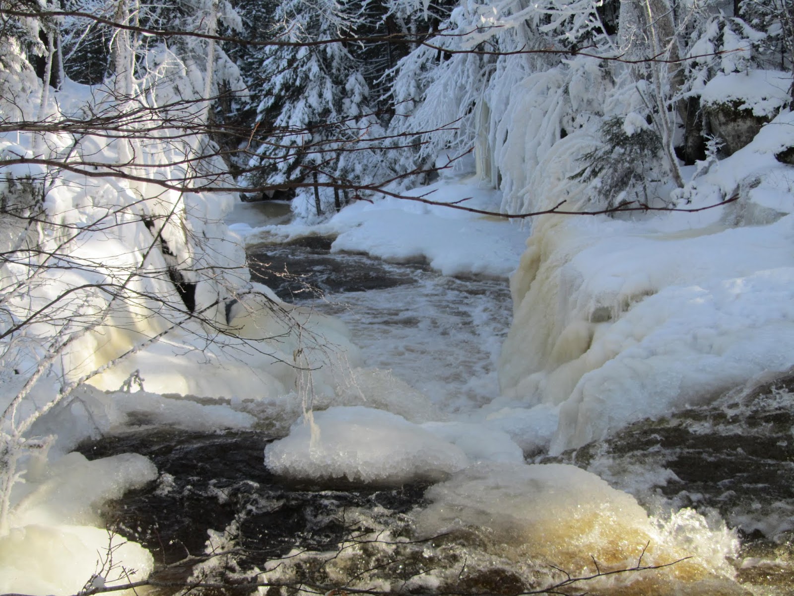
Continuing on the main loop from the bridge, after less than a tenth of a mile, the ski trail turns left. A path heading straight leads a couple hundred feet to the top of Winding Falls. Although not terribly tall, the river narrows into a gorge at the falls. This allows an impressive volume of water to rush over the falls. As its name implies, the river makes several twists as it winds its way through the short gorge. Due to its winding nature, taking in the entire falls proves next to difficult, particularly in winter when snow and ice make difficult footing. Nice ice patterns cling to the rocks near the falls from freezing mist.
 |
| The falls from above |
 |
| Looking across the falls |
 |
| Looking at the ravine below the falls |
 |
| Top of the falls |
 |
| The lowest drop of the falls after the gorge during my November trip |
To rejoin the loop, backtrack to the ski trail. The trail drops rather steeply from the bluff at the top of the falls to the river below. In the icy conditions, this descent proved treacherous. The river widens below the falls. In untracked snow, finding the trail may be a little tricky below the falls due to a blowdown, but the route hugs the river. Looking upstream, the falls remains out of sight with the expecption of the final small drop below the gorge.
 |
| Looking back at the bottom drop of Winding Falls |
 |
| The trail follows the river bank |
 |
| Calm section of the Bog River |
The trail generally stays close to the river. The sun warmed up by the time I reached this leg of the loop. The shaded sections still held hard ice while the open areas turned the snow to mashed potatoes. This added another challenge to the less than stellar conditions. Sections of the trail close to the river that received more sun started to show bare ground as the snow receded. The trail through here was originally an old informal ski trail. In addition to the DEC trail markings. Old markers from the past occasionally mark the route. Unlike the first several legs of the loop, the trail through this stretch remains narrow like a hiking trail. This stretch may be a little tricky for less experience skiers even in good conditions due to the narrow trail and a few quick transitions.
 |
| Remnants of when this was a local's trail before the DEC marked it |
 |
| One of the worst spots for skiing along the loop |
 |
| Skiing along the river |
 |
| Rapids on the Bog River |
The trail occasionally veered away from the river to negotiate small drainage. These drainages feature, short, but steep transitions. In the shelter of the forest, these steep sections remained quite icy and tricky to manage, especially if the sun poked through the trees turning the ice to mashed potatoes in a moments notice. As the river approaches rapids, a few portage trails overlap the ski trails. Pay attention as the portage trails sometimes split from the ski trail.
 |
| Sketchy conditions close to the river |
Eventually the trail pulls away from the river and travels along wider logging roads that are no longer used. The forest in this section had less dense trees since it was probably logged not long before the state took over the land. This allowed better snow condition with less shady areas. The skiing was quite nice on the more uniform snow. A few bare spots started to peek through the logging roads in less shady stretches.
 |
| A look back at my tracks |
 |
| Patches of bare ground |
The trail finally drops back to the river. The fairly wide Bog River remains open much of the winter. A large bridge from the logging days spans the river here allowing for a safe crossing. This is the same bridge that you pass in the first tenth of a mile. Crossing the bridges leads you back to the start of the loop. A left turn leads a a few hundred yards back to the trailhead.
 |
| Goodman Bridge over Bog River near beginning/end of loop |
 |
| Looking downstream on the Bog River from the bidge |
 |
| Falls from inside the gorge on my November hike |
Because this area was a fairly recent state transition, its difficult to find trail information on this area. Most maps, including the National Geographic map of this area, don't show the trails. As of this post, a few online resources offer incomplete data on the trails, including Hiking Project. The most complete description I found, with a map and alternative side trips, can be found in "50 Hikes in the Adirondack Mountains" by Bill Ingersoll.
 |
| A look down the falls in November |
When snow doesn't cover the ground, the loop makes a nice hike. The route passes numerous wet sections which would probably equate to a buggy hike in summer. I hiked it in November with a frozen ground and conditions were perfect.
 |
| Heavy ice during a trip earlier in the winter |
 |
| The falls in the colder part of winter |
 |
| More ice in early winter |
Winding Falls is known locally as Pa's Falls. Although not visible in the winter, three plaques near the top of the falls honor various fathers. If a search of Winding Falls fails to find details on the area, look up Pa's Falls.
 |
| Plaques at falls |
If you enjoyed this post, check out and "LIKE" Tomcat's Outdoor Adventures on Facebook where I post more frequently and revisit past adventures.


