Too much time has passed since I last hiked, and it's been ever longer since I was on a summit. Although I have done a few short outings nearby since, my last real hike was March 1st. That was a rather tame hike in Brown's Canyon National Monument. My last summit was on Big Baldy Mountain on Valentine's Day. It was the first half of January since I was above treeline.
Since the beginning of March, I have been working six days a week most weeks. My time has been rather limited. During this time, I have been on my mountain bike a handful of times, but couldn't find the time to get in any longer hikes. I needed to hit the trail soon.
Last week I started throwing around ideas for a hike with my friend Drew Petersen. We had talked about hiking St Charles Peak in the Wet Mountains, but never got around to it. He hiked it before and deemed it a worthy summit to revisit.
St Charles Peak, at 11,784', is relatively low by Colorado standards. It ranks as the 1417th highest mountain in the state, which isn't all that impressive. It is however the second highest mountain in the Wet Mountains and tall enough to offer two summits above treeline with outstanding views.
Even after a couple of spring snows in the past month, we figured St Charles Peak would be a safe bet to eliminate the excessive snowy conditions of higher mountains this time of year. Just a few days earlier, Drew climbed 9600' Curley Peak and saw no snow at all. We expected a few patches on the upper reaches of St. Charles, but hopefully no prolonged stretches of deep snow.
On Friday morning, May 13th, we met up and headed to St Charles. The trailhead is just over 9000' in elevation along route 165 near Rye, Colorado. The sheltered roadway had a few patches of snow visible in the shadows but nothing to worry about.
We began our hike and almost immediately ran into patches of snow along the heavily forested St Charles Peak Trail. The trail itself was mostly dirt, but there was some snow on the trail. The terrain along the trail is fairly pleasant, almost reminiscent of the terrain in northern New England. I don't think we made it even half way before we were consistently in snow and the entire ground was covered. Travel wasn't too bad though as the snow was generally firm in the cooler morning temperatures. When the trail broke into a sunnier stretch, we would posthole, but it wasn't a serious problem earlier on the hike.
 |
| The snow is fairly consistent early |
 |
| Drew along the trail |
 |
| It didn't take long for 100% snow coverage |
We had footsteps from the previous day in the snow to confirm the route. Abruptly the tracks ended in a section of steep postholes. At this point the trail was no longer visible. We snooped around and couldn't find the trail ourselves. We decided to backtrack to the last obvious turn and found a clear corridor that appeared to be the trail. The previous hiker, missed this turn.
 |
| End of the line for the last hiker |
 |
| Typical trail |
 |
Lots of shade on the way up kept
the snow firm |
 |
| No more tracks to follow |
The rest of our route required some moderate route finding in the increasingly deep snow. This area is heavily wooded and the trail route was never too obvious, and easy to lose when the trail made a switchback. Too add to the difficulty, the temperatures were warming and snow softening. Postholing became more frequent.
 |
| Typical knee deep posthoole |
Between the two of us, we have a lot of hiking and routefinding experience. We seemed to stick pretty close to the trail most of the way. Occasionally we would see a hash mark or ribbon on a tree to confirm our path. We topped out on a high point along the route around 11,400' where the two summits of St Charles were visible and confirmed we were headed in the right direction.
 |
| View of the lower summit |
 |
Taking a break to determine our route
to the first summit (Photo by Drew) |
We traveled slightly off the trail corridor on a more direct route toward the first summit of St Charles. There are two small alpine areas on St Charles. We reached slightly lower summit first, which is over 11,600'. This summit is no more than a couple hundred feet above treeline. This lower summit features a few rock formations and is more attractive than the true summit. Far flung views immediately open up above treeline. The snow was more consolidated above treeline and the postholing was minimal.
 |
| Breaking out of the trees |
 |
| Approaching rock formations |
 |
| The Sangres in the distance |
 |
Near the crest of the first summit
(Photo by Drew) |
 |
| Rock outcroppings |
We crossed the lower summit and headed toward the higher true summit a few tenths of a mile away. We dropped briefly back into the trees on a direct route since the trail was hidden under at least three feet of snow before climbing the short distance to the summit.
 |
The Crestones, Humboldt, Kit Carson/Challenger,
Centennial Mt Adams, Colony Baldy |
 |
| Distant Pikes Peak |
 |
| Looking back along first summit toward the plains |
 |
| True summit ahead |
With all the snow, we got to the summit a little slower than anticipated. The trail climbs around 3000 vertical feet from the trailhead to the summit. Our route by trail is about 5 miles to reach the summit. We probably cut that a little shorter since we were traveling over snow and missing some switchbacks on a slightly more direct route.
 |
| Most of the Sangres are visible |
 |
At the true summit, standing on top of at least 3 feet of snow
(Photo by Drew) |
 |
| Taking in the view (Photo by Drew) |
Even though the lower summit is slightly more attractive, the true summit has better views. There is a small tower and outhouse sized building on the summit that is only a minor distraction. The alpine area at the is a relatively flat snow covered meadow.
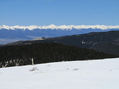
The views from the summit, particularly with the surrounding mountains covered in heavy snow, make this hike worth it. The Sangre de Cristos dominate the view with good looks at the Crestone, Humboldt, Kit Carson group of 14ers. Just below the Crestone group, the Blanca group looms large.
Further south, Culebra Peak and its neighbors in the Culebra Range are easy to identify. I'm not positive, but I think the Southern Sangre Range peaks around Taos, New Mexico were just beyond the Culebra Range. The fairly large alpine summit of Greenhorn Mountain, the highest summit in the Wet Mountains seems close to the south. The Spanish Peaks stand just beyond Greenhorn.
 |
| Sangres |
 |
| Mt Adams, Horn, Fluted Peak, among others |
 |
| Cluster of 14ers in the Crestone Group |
 |
| Crestone Group close up |
 |
| Blanca Group of 14ers |
To the north the views are quite far reaching. A good chunk of the Sawatch Range is visible and identifiable from Shavano to Harvard and beyond. Nearly the entire northern reaches of the Wet Mountains are visible up to Curley Peak. Pikes Peak looms beyond the Wets. Although I can't positively identify the individual mountains from that distance, the Mosquito and Front Ranges are visible. The plains spread forever to the east with Pueblo Reservoir seeming quite close.
 |
| Further north in the Sangres |
 |
| The Sangres stretch out forever |
 |
| North toward Pikes Peak and northern Wet Mountains |
 |
| Pikes Peak close up |
After enjoying the summit views, we began our descent. Traveling wasn't too difficult until we descended below treeline. A few of the steeper sections we could boot ski for short distances. Quickly however we got into increasingly softer snow. Much of the ground on the upper half of the hike had at least three feet of snow. The postholing became quite nasty, rarely getting in more than a few good steps before sinking repeatedly well above the knee. Luckily we had gravity on our side and it wasn't as exhausting as it could have been. As we made our way down the lower half of the route, we faced less snow and eventually more bare ground.
 |
| Retracing our tracks between the summits |
 |
| Heading back down the first summit |
 |
| A marmot on the the rock outcropping keeping an eye on us |
Despite the added difficulty of deep snow, I had a good time on this hike. I was long overdue for a hike and this trip was much needed. Having another person to share in the postholing also made that experience less frustrating.
Luckily we were faced with a great spring day with little wind and warm temperatures. Neither of us had snowshoes or gaiters, which would have made life easier. Neither of us expected this much snow at this elevation in a southerly location. Mistakenly, I used the 10-11,000' Arkansas Hills near my house to judge snow. They are bare right now but get very high sun exposure compared to the St Charles Peak area. Even with the more challenging conditions, we climbed the 3000 vertical feet and traveled nearly 10 miles in a little over 5 hours. In much better conditions, Drew was able to do the same trip in less than 4.
The trailhead for this hike is just a few miles away from an interesting Colorado landmark called Bishop's Castle. The Castle was built over the years by an eccentric local named Jim Bishop. If you've never heard of or seen it, it looks like a medieval castle built of rock and iron complete with 160 foot towers. Since we drove right by it, we stopped to check it out. The castle is open to explore to the public and there is a donation box. Exploring the castle doesn't take too long but may not be for the faint of heart or those afraid of heights. You can climb the spiraling staricases in the towers to a bridge and lookout near the highest part of the castle. The lookout, and especially the bridge, are quite shaky as you walk over them.
 |
| Bishop's Castle |
 |
| Tower at the castle |
 |
| Inside the main room of the castle |
 |
| The main room in the castle courtesy of Drew |
 |
| Yours truly on the shaky bridge courtesy of Drew |
 |
| Inside the highest tower courtesy of Drew |
This is my third hike in the Wet Mountains and I'm sure it won't be my last. Their lowly stature, when compared to other Colorado Mountain ranges, seems to keep them off the radar. I have found the Wets to be a worthwhile destination, particularly in the off season. If nothing else, the Wets have some of the best views of the impressive Sangre de Cristo Range. (Click on
Hiking Tanner Peak in Memory of Tanner Brown and
New Years Day Hike of Curley Peak to see my other hikes in the Wet Mountains.)
 |
| Looking into the heart of the Sangres |
 |
Crestone Group close up
|
If you enjoy my blog check out and Like Tomcat's Outdoor Adventures on Facebook for more frequent updates and photos.


