The Otter Creek Wilderness consists of more than 20,000 acres in the Monongahela National Forest, just east of Elkins, West Virginia. As its name implies, the Wilderness is centered on its namesake creek. Otter Creek flows north through the center of the Wilderness with McGowan Mountain rising to its west and Shavers Mountain to the east.
Despite 45 miles of trails running through the Wilderness, the area doesn’t see that many visitors. The area has a reputation for overgrown and muddy trails, minimal signage, and numerous fords. This reputation keeps out most casual hikers. The lack of visitors makes the area a good place to find solitude for those comfortable on primitive trails and not minding the wild nature of the Wilderness.
Despite living only a few miles from the Wilderness for about a year now, I still hadn’t explored the area. I finally changed that recently. On July 23rd, I set out on a long day hike at Otter Creek. My plan for the day was a roughly 19 mile loop starting at the Condon Run Trailhead at the south end of the Wilderness (see my route at the map near the end of the post.)
The main southern access for the Otter Creek Wilderness is reached about 20 minutes or so from the middle of Elkins off of US 33. The Condon Run Trailhead is only about two miles off the highway near the USFS Bear Heaven Campground. My loop followed the eastern boundary of the Wilderness along Shavers Mountain before dropping to the heart of the Wilderness along Otter Creek. I'd close my loop by following Otter Creek upstream back to Condon Run.
I began hiking around 9AM. From the trailhead, I almost immediately turned onto the Hendrick Camp Trail. The Hendrick Camp Trail crosses Otter Creek's upper reaches and passes through wet and muddy terrain. It wasn't long before I slipped on a wet route and submerged a shoe. I was surprised that there was actually a bridge and even a few blue markers. I'm guessing the trail here actually stays just outside of the Wilderness boundary.
 |
| At the trailhead |
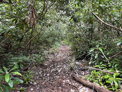
I was pleasantly surprised that the rhododendrons were still blooming. The rhododendrons turned out to be a highlight of the hike. I mostly encountered white flowers at the start of the hike. I passed through some rhododendron tunnels as well.
 |
| Rhododendron blooms out of the gate |
 |
| Bridge over the upper reaches of Otter Creek |
 |
| The trail didn’t stay this nice |
 |
| Early wet section |
The Hendrick Camp Trail travels just over a mile as it climbs gradually to the Shavers Mountain Trail. Although a little brushy at times, the trail never was too difficult to follow. As I climbed away from Otter Creek, the trail was less muddy. Once in the Wilderness, signage becomes quite limited. I reached a T with no signage. This was the intersection of the Shavers Mountain Trail.
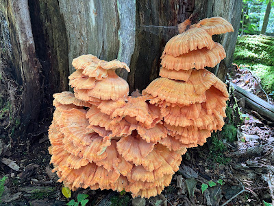
I would follow the Shavers Mountain Trail for the next six miles. The trail generally follow close to the crest of its namesake mountain. On the first half of the trail, I topped out around 3,700' in elevation. Despite reaching a respectable elevation, there aren't really any views from the ridge. Even with no views, the ridge still provides nice scenery. The dense thickets of rhododendrons continued along the crest with plenty of blooms. I also encountered several species of fungus. I even saw a hummingbird enjoying the flowers as well.
 |
| First of many mushrooms |
 |
| Chicken of the Woods |
 |
| Big cluster |
I read about people having difficulty navigating through the Otter Creek Wilderness due to overgrown and unmarked trails. While I definitely encountered some dense foliage that blocked the trail, I didn't have much difficulty navigating with just a map. While most of the Shavers Mountain Trail passed through rhododendrons and hardwood forest, it also passes through stands of spruce. It was only in the spruce that the trail was maybe a little trickier to follow as there wasn't always an obvious tread. Using a little common sense following the topography of the ridge, I always figured out where the trail went in quick order.
 |
| One of the brushiest sections |
 |
| Entering spruce |
 |
| Spruce and rhododendrons |
 |
| Pretty moss-lined trail |
 |
| A rhododendron just starting to blossom |
 |
| Pretty pink flowers |
 |
| Passing through a tunnel |
About half way through the Shavers Mountain Trail, it descends to a low point on the ridge at Mylius Gap. Here the trail reaches an unsigned, four-way intersection with the Mylius Trail. The Mylius Trail descends left toward Otter Creek or right to the Mylius Trailhead and the eastern access point to the Wilderness.
 |
| Cool fungus |
 |
| Club moss |
I continued straight on the Shavers Mountain Trail. The trail gradually climbed back to the ridge. The trail traveled through much of the same vegetation. Generally I passed through more hardwoods and rhododendron thickets with occasional stands of spruce. Hiking along the ridge, the trail was mostly dry. I encountered a few wet spots, but nothing that wasn't avoidable. In the stands of spruce, bright green moss lined the trail in several spots.
 |
| Getting a little brushy |
The day was supposed to be relatively hot and humid, with valley temperatures reaching the upper 80s. The forecast looked to be mostly sunny, with no rain predicted. As is often the case in the mountains, the skies looked a little menacing. Dark clouds moved in. I even heard one rumble of thunder in the distance.
 |
| The orange color pops in the forest |
 |
| Dense moss |
After traveling about seven miles for the day, I was surprised to see a sign. There isn't an intersection, but the Shavers Mountain Trail ends and becomes the Green Mountain Trail. Looking at the map, Green Mountain appears to be a prong of Shavers Mountain. There really isn't much of an elevation transition between the two mountains other than the trail heads in a more westerly direction after heading north for the last six miles.
 |
| The first sign I saw since entering the Wilderness |
The Green Mountain Trail traveled through some of the best rhododendron thickets of the hike. I passed through several long tunnels. The flowers were beautiful with more pink blooms than white.
 |
| Cluster of pink rhododendron flowers |
 |
| Another nice rhododendron tunnel |
 |
| Flower petals that have fallen |
After hiking a little over a mile on the Green Mountain Trail, I reached a clearing with another unmarked junction. Here the Possession Camp Trail descends over three miles to the southeast to Otter Creek. I'm guessing the clearing at the junction might have been the site of the Possession Camp. The area around the clearing sits by a nice, flat stand of spruce that would make a great place to camp, complete with a large fire ring. A nearby unmarked trail led to another campsite just off the main trail.
 |
| Nice campsite |
I continued straight on the Green Mountain Trail. The trail stayed relatively flat for the next mile, before beginning a fairly steep and rocky descent toward Otter Creek. The trail passed through a section that looked like an old tote road with sections of water flowing through it. I encountered more mud in this stretch as well. The wet rock was fairly slick. The trail continued through beautiful stands of rhododendrons with pink flowers.
 |
| Bright pink bloom |
 |
| The rhododendron tunnels never get old |
The last mile to mile and a half of the Green Mountain Trail was the steepest terrain of the day. I was a little surprised to see a Forest Service employee hiking the opposite direction through here. I think he was more surprised than me though. I'm sure he wasn't expecting to see anyone else and I startled him when he saw me.
 |
| Tiny stream cascading down the mountain |
 |
| Black cohosh |
I finally reached the end of the Green Mountain Trail after roughly 11.5 miles of hiking on the day. The trail ends at the Otter Creek Trail. If hiking from the opposite direction, the Green Mountain Trail isn't that obvious. A small cairn marks the junction, but it's easy to miss. A couple of small side trails to campsites might add to the confusion. This was also the low point of my loop around 2.000’ in elevation.
The Otter Creek Trail travels nearly 12 miles though middle of the Wilderness and is never too far from the creek. I headed south along the creek to hike the southern 7.7 miles of the Otter Creek Trail and close my loop. Within a few minutes, the trail crosses Otter Creek for the first of three times.
Knowing I had numerous wet fords in store for the day, I brought a pair of flip flops for the crossings. The water at the first crossing rose to just below my knee at the deepest, but was mostly just over the ankle. The water was surprisingly cold considering how hot and humid the day was. After crossing, I stopped and ate some lunch.
 |
| First crossing of Otter Creek |
 |
| Small cascade above the crossing |
 |
| Looking downstream at the crossing |
The trail traveled close to the creek, but I could rarely reach the banks. Dense rhododendrons made it nearly impossible to reach. It sounded like the river had some nice tumbling rapids and cascades, but I couldn't see them. With the creek just out of reach, I focused on the mushrooms and flowers. A couple of times, the trail climbed away from the creek to avoid steep terrain that rose from the banks, At one point a few drops of rain fell, but it lasted only about 30 seconds
 |
| More interesting fungus |
 |
| A big slug enjoying the mushroom |
 |
| Bee balm |
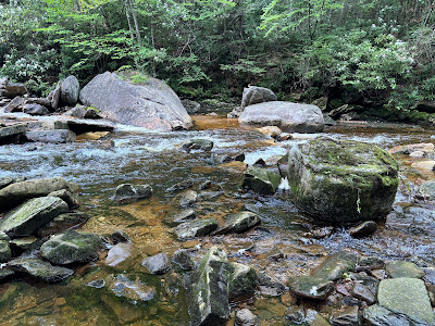
Eventually I reached a few spots where the creek was more accessible. It seemed like a few herd paths led to nice spots along the creek with rapids, cascades and pools. I took advantage of any spot I had to reach the creek and enjoy the tumbling mountain stream.
 |
| Cascade falling between rocks |
 |
| Looking downstream with ominous clouds in the distance |
 |
| Nice Cascade |
 |
| Looking at the cascade from further downstream |
Besides the fords on Otter Creek, there was also a crossing of Moore Run. This isn't very wide, but there are some deep holes in at the crossing and its difficult to move up or downstream due to vegetation. I managed to get across on a risky rock crossing, but almost ate it. The rocks were wet and extremely slick. The rock that I slipped on was particularly high out of the water. A fall could have been painful. Luckily my poles saved me. I wouldn't recommend rock hopping unless the water level is very low.
 |
| More interesting fungus |
 |
| A nicer section of the Otter Creek Trail |
The trail traveled about 3-3.5 miles between fords of Otter Creek. The best waterfalls came not too long before the second ford. The nicer waterfalls had pretty good herd paths for easy access. The biggest waterfall dropped about 20 feet.
 |
| No shortage of scenic spots |
 |
| The largest waterfall I came across |
After the 20-foot waterfall, I soon reached the second ford of Otter Creek. Although not quite as wide, the second crossing was a little more challenging, but by no means that difficult at the current water levels. A few deeper pools stood in the rapids right at the crossing. I went upstream a few feet to cross in the more consistently shallow rapids.
 |
| Second ford |
 |
| Upstream of the ford |
There are several large campsites just upstream from the second ford. I passed several tents with gear outside, but I didn't see or hear anyone around. I don't know if they were sleeping or off exploring. It looked like at least two separate groups.
The trail passes close to the river with a few access points to the water. There were a couple nice cascades with deep pools below them. It looked like a good place to swim. There were a lot of campsites nearby and I could see the appeal of camping nearby these cascades.
 |
Yet another pretty cascade with a deep pool
below it |
 |
One more cascade just upstream from the last one
with another nice pool below it |
The trail didn't travel too far before the third crossing of Otter Creek. This final crossing was slow and shallow with no real difficulty getting across. I did have one more crossing of yellow Creek near the end of the hike, but it was shallow enough to easily rock hop.
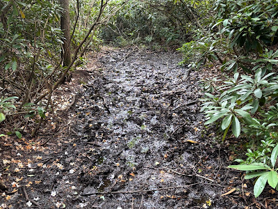
Since the trail generally sticks close to Otter Creek, it generally stays flat. This area was once heavily logged and the trail is a remnant of an old logging road at places. The Otter Creek Trail lives up to its muddy reputation at many places along the creek. A few times it was impossible to avoid the thick mud. Dense rhododendron thickets made it impossible to bypass the mud at places. Fortunately the worst stretches didn't last too long.
 |
| A particularly muddy section |
As the trail follows Otter Creek upstream, the creek becomes slower. Near the end of the hike, I even passed through some marshy meadows. While still pretty, the trail looks less like a tumbling mountain stream and more like bottomlands as you get closer to its headwaters.
 |
| The trail right on the banks of the much slower creek |
 |
| Vibrant orange Chicken of the Woods |
 |
| Otter Creek flowing lazily in a meadow |
For the final 1/4 to 1/2 half mile, the trail leaves its singletrack tread and follows a service road to the gate at the trailhead. I'm not sure, but I'm guessing the trail leaves the Wilderness boundary at this point. I finished the hike just after 430PM.
My hike totaled about 19 miles. While I hiked the loop in a day, there are plenty of campsites, to stretch it into an overnighter. I hiked several days after any rain and the conditions weren't too bad. I wouldn't want to hike in the area after recent heavy rains or after the snowmelt. The trails would pretty messy and the fords challenging.
Otter Creek is a pretty mountain stream that's worth checking out. While I was lucky to catch the rhododendrons while they were blooming, hiking through the rhododendron tunnels is always a neat experience. I always appreciate hikes with a variety of mushrooms as well. I enjoyed the solitude and wild nature of this trip.
The area has a reputation of trails being difficult to follow. I had no problems navigating the area with just a good map. While I did encounter a few signs at junctions, several of the junctions were not signed or only had cairns. If you aren't confident navigating in the backcountry, you may want to explore the area with someone else or utilize a GPS or navigation app. If you are looking for solitude and a Wilderness area that truly feels wild and off the beaten path, I would recommend checking out the area.
 |
| My hike marked in red, click MAP for better detail |
If you enjoyed this post, check out and "LIKE"
Tomcat's Outdoor Adventures on Facebook where I post photos more often and revisit past adventures.


