While the Sangre de Cristos are a stunning mountain range, hikes into their higher elevations are a challenge, particularly with snow on the ground. When I'm looking for a quick outing in the forest or a quick snow season escape, I frequently visit the lower elevations of the Sangre de Cristos. The east side of the range is anchored by the Rainbow Trail. The Rainbow allows easy access to several off the radar, lowly peaks that often have nice scenery. There is also access to interesting areas directly from US 50 in Bighorn Sheep Canyon.
Here are some of those hikes from the past year. Each of these hikes I was accompanied by my dog Choya. Choya is always up for an adventure. Taking Choya on a hike seemed like a good opportunity for me to visit these places, most of which I never visited before. I didn't go into great detail on a lot of these hikes. I did share a lot of photos however.
Badger Gulch Peaks
Badger Gulch is accessed directly from US 50 in Bighorn Sheep Canyon. Unless you know it's there, it's easily passed by while driving on US 50. The gulch drops down from the Sangre de Cristos until it reaches its end in the Arkansas River just west of Howard, CO. It enters the river near Badger Creek, which flows into the opposite side of the river.
My main reason for checking out Badger Gulch was to access some low peaks in the area. There are three unnamed peaks that form the south side of Bighorn Sheep Canyon. The peaks are just not named and referred to by their elevations; UN 7763', UN 7580', and UN 7363'. The crest of the northern Sangre de Cristos, just south of these peaks rises to over 13,000' at Hunts Peak.
 |
| The Arkansas River near the mouth of Badger Gulch |
Despite their lowly elevation, I wanted to check the peaks out. UN 7763' and UN 7580' make up the south wall of the canyon. The both feature rocky cliffs that rise nearly 1000' above the river. UN 7363' is the last high point before the canyon opens into the Pleasant Valley in Howard.
 |
| Choya enjoying the snow in Badger Gulch |
My original plan was to hike all three peaks in one hike. I began with the most westerly of the three, UN 7763'. After traveling a short distance in the gulch, I found a reasonable exit and began climbing. Choya was still fairly new to hiking at this time. The climb gains nearly 1000' in about 3/4 of a mile. There is no trail. Once out of the gulch, the route encounters considerable talus. Above the talus, much of the terrain is carpeted with prickly pear cactus. I had a difficult time finding a path to avoid the cactus for Choya.
We hiked on an overcast day, so the high mountains were obscured. The summit offers a neat vantage point of the canyon and river, about 1000' below. I was surprised to find a summit register. On the descent we encounter more cactus and talus. Since Choya fairly new to hiking and just hiked two days earlier, I didn't want to push him since the talus was pretty significant. Rather than risk Choya getting injured, we stopped after climbing UN 7763'.
 |
| Looking upriver |
 |
| The Arkansas from the summit |
 |
| Cliffs above US 50 |
 |
| UN 7580' |
 |
| Descending an icy spot in the gulch |
A month later, we returned to hike UN 7580' and UN 7363'. Again we began with a hike up the gulch. We first climbed UN 7580'. Because of heavy cliffs on the east and north sides of the peak, we climbed from the south. Approaching the peak from the south has a fairly easy route. Fortunately, there was far less cactus.
 |
| Narrow rocky stretch in the gulch |
 |
| Another narrow spot |
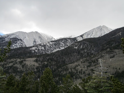
 |
| The Sangres |
This time we had clear weather. The views were quite impressive for such a low peak. There are great views of the high peaks of the Sangres and Sawatch range. The views up the canyon are interesting. There is a unique vantage looking north up the Badger Creek basin. Just below the summit lies an interesting cliff band.
 |
| UN 7763' |
 |
| Another shot of the Sangres |
 |
| Sawatch Range including Shavano and Antero |
I descended along the ridge of UN 7580' and reached another gulch below UN 7363'. It's a short, punchy climb to gain the ridge of UN 7363'. I ascended to a small saddle before making my way to actual summit. From the gulch, it's just over a 1/4 mile of travel but gains more than 400 feet. The summit of UN 7363' is not quite as impressive as UN 7580', but still offers nice views into the Pleasant Valley around Howard.
 |
| Looking up the Badger Creek Basin |
 |
| Looking upriver |
 |
| Plenty of snow at higher elevations |
 |
| Sangres |
I attempted to descend directly toward the gulch and US 50. I was quickly cliffed out and didn't want to take any chances with Choya. I retraced my steps to the gulch. I followed the gulch to the highway near the power substation. From there is was less than a mile back to my car at Badger Gulch.
 |
| Cliffs on UN 7363' |
 |
| Pleasant Valley around Howard |
 |
| Cliffs above |
These three peaks may not be the most impressive given the abundance of mountains in Colorado but they were worthwhile trips. It's always nice to explore places off the beaten path.
 |
| A happy Cactus Mutt |
 |
| Shavano |
Peaks along the Rainbow Trail
Another place I visit occasionally for a quick hike is the Rainbow Trail near Hayden Creek. The Rainbow Trail itself isn't all that impressive. It travels along the eastern side of the Sangre de Cristos close to 100 miles. It sees a fair amount of dirt bike traffic and is in rough shape at places. The area to the south of Hayden Creek saw some serious damage from the 2016 Hayden Pass fire which burned over 16,000 acres. The trail passes near a couple of small summits that offer decent views of the Sangres.
 |
| Snowy Sangres along the Rainbow |
 |
| Late summer view |
To the south of the Hayden Creek area, the Rainbow Trail passes directly through some of the fire area. I first hiked this early in the spring to see the damage. I was surprised at how damaging the fire was. In the worst areas, the ground was charred black with no remaining vegetation and tree skeletons. I returned in late September. A very wet monsoon season helped with some growth. It also helped to heavily erode the trail.
 |
| Traveling into the burn |
 |
| Only skeletons of trees remain |
 |
| Not much left of this tree |
 |
| View from Table Mountain |
 |
| Choya hiking in the burn |
 |
Severe erosion on the Rainbow Trail
after monsoon season |
 |
| Late season revegetation after the monsoon |
 |
| Burnt trees on Slide Rock Mtn |
There are two high points in this stretch. The first is 8990' Table Mountain. The actual summit is just a few feet from the trail. The trail passes the treeless summit, offering nice views toward the Sangres. The other minor summit is 9473' Slide Rock Mountain. Slide Rock is a short bushwhack from the trail just before it drops into the Cottonwood Creek drainage. Slide Rock was in the path of the fire and is covered with charred trees. Nice views of the higher peaks can be seen through the burned forest. From the road at Hayden Creek, a trip to Slick Rock Mountain is nearly 10 miles round trip and climbs more than 1500 feet. Although not a tough hike, the damage and washouts in the burn scar, particularly on the initial climb make for some rough footing.
 |
| A snowy Rainbow Trail in mid April |
 |
| Scrubby vegetation that avoided the fire |
 |
| Yucca on Table Mtn |
 |
| Looking at Slide Rock Mtn from Table Mtn |
 |
| Choya on Table Mtn |
To the north of Hayden Creek, the trail climbs 2.5 miles towards the Bushnell Lakes Trail. Rather than heading toward Bushnell Lakes, an unmarked trail leads uphill in the opposite direction. Following this trail to its end and continuing uphill to the high point leads to 9510' Hamilton Baldy. Although treed, nice views of the Sangres can be seen from Hamilton Baldy. Although a tame hike compared to the higher summits of the Sangres, the hike to Hamilton Baldy is a pleasant 7 mile round trip with numerous streams along the way and a nice place for a quick walk in forest.
 |
| A thicker Choya in March |
 |
| Snowy March Rainbow Trail |
 |
| Much more snow in March |
 |
| Views from Hamilton Baldy |
 |
| I think this is Mt Otto |
 |
| The white area is snow in the Hayden Pass burn |
 |
| The spine of the Sangres is just a few miles away |
 |
| Looking toward the burn in the Nipple Mtn area |
 |
| The dim light makes this photo look black and white |
 |
| View south from Hamilton Baldy |
 |
| Bushnell and Otto |
Rainbow Trail- Bear Creek
Another quick outing close to Salida is the Rainbow Trail in the Bear Creek Drainage. In the past few years, the Columbine Trail opened and connects to the Rainbow. By hiking up the Columbine to the Rainbow, then descending Bear Creek Road, there is a nice 8 mile loop. In the summer, this area can be busy with mountain bikes so I prefer to hike it in the off season. The route climbs to just over 9000 feet. The trails cross numerous small streams. Much of the route is in a mature forest with a few meadows along the Rainbow.
 |
| Simmons Peak above the Rainbow |
 |
| Mountain Ball cactus |
 |
| Cluster of Mountain Ball |
 |
| Buffalo Peaks |
 |
| Mt Princeton above Chalk Cliffs |
While in the snowfree months I usually mountain bike this area, the loop is enjoyable in the winter months for a quick hike with Choya. There are views to the Sawatch Range as well as the Buffalo Peaks in the Mosquito Range from the meadows. This is a good destination when you don't want to commit to conditions in higher elevations.
 |
| Untouched snow |
 |
| Very little snow in late December |
 |
| Methodist Mountain from a clearing |
None of these hikes are epics. They are quick escapes. Although the Badger Gulch hikes are completely off trail and involve minor route finding, none of these hikes should take more than a few hours to a half day.


No comments:
Post a Comment