Living in the Sangre de Cristos, I am naturally drawn to them. They are an impressive mountain range after all. I have hiked and climbed more peaks in the Sangres than any other range in Colorado.
I have a climbed many of the 13,000 foot peaks in the northern end of the Sangres between Westcliffe and Salida. There was one particular group of 13ers that I had on my short list of summits. De Anza Peak, Gibbs Peak, and Mt Marcy. They were the missing link of peaks that I still wanted to climb in this stretch of the Sangres.
These particular peaks are somewhat difficult to access. I prefer to climb from the eastern side of the Sangres. These peaks stand between areas without good road access and require long approaches. The western side of the range isn't much better. The shortest hike to reach any of these peaks requires a minimum of 13+ miles and a mile of elevation gain. It doesn't seem too bad to do one of these three peaks in a day. But climbing all three in one trip makes for a tough day.
I also had a push to climb Mt Marcy. In the future, I'll be moving to the middle of the Adirondacks in New York. The highest summit in New York is also called Mt Marcy. There is no shortage of hiking in the Adirondacks. I'm sure I'll climb Mt Marcy not too long after I arrive there as I won't live very far from it. I thought it would be nice to hike the much lesser known but much higher Colorado Mt Marcy before climbing the lower but better known New York high point, Mt Marcy.
After some deliberation, I decided to tackle these peaks from the western side of the range. This seemed like a slightly shorter option without having to reclimb any summits and possibly keep the trip under 20 miles. I initially planned on the trip on my birthday, May 29th. Morning overcast and precipitation on the summits had me postpone until the following Monday, which looked like a better day.
Sunday, the day before I hiked, was a dreary day. The Sangres were socked in most of the day and rarely visible. The weather broke later in the day and I was able to see the peaks above my house. I was happy to see that there wasn't any snow.
On Monday, June 4th, I woke up at 4AM to get an early start for the longer day I had planned. At a minimum, I knew I had at least 17 miles to cover and over 6000 vertical feet of climbing. I also had my dog Choya (the Cactus Mutt) with me for this trip.
As I drove toward the Cotton Creek Trailhead in the morning, I made my way south of Salida and over Poncha Pass. From Poncha Pass, you get a nice long view down the Sangres. I immediately noticed the peaks to the south of Hayden Pass were sporting a fresh covering of white on the higher summits. It didn't look like too much snow, but possibly enough to encounter some slippery sections on the summits.
The trailhead wasn't too hard to find, although I recommend carrying a map with the roads. Sagauche County has a strange road system. Once off of Colorado 17, I followed County Roads DD.2, 61, and CC. There is a Forest Service sign directing you to Cotton Creek but it is misspelled "Cotten Creek". Nonetheless, with a map, finding the trailhead is fairly straightforward. The last two miles gets bumpy but should be passable with any vehicle if you take your time. Not long before reaching the trailhead, I saw three pronghorn.
 |
| Pronghorn |
I began my hike about 615AM. The hike began on the Cotton Creek Trail, which begins at the signed trailhead around 8600' in elevation. The San Luis Valley in treeless and barren. The Cotton Creek Trail starts immediately in the forest which is quite lush near the creek.
 |
| Trailhead sign |
It was cool when I left home, in the upper 40s. It was sharply cooler when I started hiking, I'm guessing in the 30s. I was on the west side of the Sangres and the range would block the sun for a while.
The trail leaves the trailhead and quickly crosses the creek on a bridge. This is the only bridge despite numerous creek crossings. The trail never wandered very far from the creek and the vegetation was quite lush and growing into the trail. Apparently the area saw a decent rainfall the prior day or overnight. The vegetation was dripping wet. Within minutes my pants were soaked from the waist down. Choya had no relief from the moisture since he is relatively short.
 |
| Wild roses |
I wasn't thrilled about being soaked first thing in the morning, especially given the cool temperatures, but trudged on. Despite being soaked, the hiking was pretty tame in the lower elevations. The climbing is very gradual along the creek.
 |
| Trailside aspens |
Not too long into the hike, we encountered our first creek crossings. The first couple were tame and could be stepped over on conveniently placed logs. Choya chose to ford since it wasn't too deep. As we moved along, the creek crossings became more challenging. The creek was running fairly high from snowmelt and rain from the previous day. I had to work hard at finding a place to cross without fording.
As I gained elevation, several of the logs that crossed the creek were coated in ice, making for rough crossings. I keep Choya leashed and would unhook him at the creek crossings. Sometimes he crosses on downed logs, other times he fords. At one point I crossed on a particularly icy log. I made it across with the aid of my hiking poles. Choya followed. He slipped and fell into the creek. It wasn't too deep, but he was thoroughly soaked. I had to ford on at least two occasions due where there were no convenient logs to step across.
The water and wet vegetation were not the only obstacles. There seemed to be an extreme amount of blowdowns. While majority of the blowdowns were manageable, they were quite abundant. Most could be stepped over or ducked under without too much effort. Choya seemed to be growing tired of them as well as he had to leap over most of them.
 |
| Common section of blowdowns |
After nearly two hours on the Cotton Creek Trail I reached the Horsethief Basin Trail. The Horsethief Basin Trail is somewhat overgrown and easy to miss. There is a broken picket marking the junction with an 856, it's trail number, The picket is in bad shape and doesn't jump out if you aren't paying attention.
The Horsethief Basin Trail was a welcome sight. The trail climbs away from the water and was much drier than the Cotton Creek Trail. The trail begins climbing with several switchbacks. As the trail climbs, there are intermittent views of alpine terrain above Cotton Creek.
 |
| Early view toward Mt Owen |
The trail reaches a meadow with views above treeline. This is Horsethief Basin. Above the basin is a long, grassy pitch that travels well above treeline. I'm guessing this is an avalanche chute. The trail switchbacks steeply, mostly through the trees. At just over 11,000 feet, I saw the first few patches of snow from the previous day.
 |
| Horsethief Basin |
I decided to bypass the trail and head directly up the chute. The pitch is quite steep but it seemed like the quicker option. Before long I started encountering more steady snow as I neared treeline. I could see the trail again at this point and soon rejoined it.
 |
| The trail visible zigzagging in the avalanche chute |
 |
| Not much snow yet in the chute |
The views get better with elevation. From the chute, Mt Neidhardt is the primary visible peak. The tallest peak in the immediate area, Electric Peak comes into view as you gain elevation. Mt Owen and its neighboring 13ers are also visible above Cotton Creek to the south. At one point I saw a larger animal run in the distance but it was too quick and far away to make a positive ID. I'm guessing it was a bighorn sheep. The marmots were also taunting Choya as we made are way above treeline.
 |
| Horsethief Trail above treeline |
 |
| Mt Owen |
 |
| Electric Peak |
The trail was mostly covered above treeline but easy to follow. Eventually the trail continues to the saddle between Electric and De Anza Peaks. The trail continues on the east side of the range into to the South Brush Creek Basin. According to the Forest Service, the Horsethief Basin Trail runs 4.6 miles from its split from Cotton Creek to the crest.
 |
| Approaching the crest of the Sangres |
 |
| Old mine |
 |
| I think this is UN 13,490' |
 |
| The trail barely visible in the snow |
Earlier on the hike, I was worried about Choya and me being wet. It was bound to windy and cooler once on the ridges and summits. The dry mountain air and a comfortable breeze had us both dry before we made it to the crest of the range.
At the crest of the range, I departed the trail. My first target was 13,362' De Anza Peak. From the saddle, De Anza Peak looks quite steep. From the end of the trail, it is nearly a mile to De Anza Peak following the ridge with 800 feet of elevation gain. There are several small bumps along the way before the steep climb up the ridge. While it looks like a knife edge from afar, the main ridge climb is far more manageable than it looks.
 |
| Gibbs in the distance and De Anza |
 |
| De Anza in the foreground |
 |
| The peaks above the Cotton Lake basin |
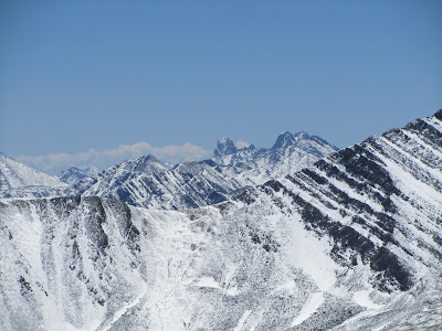
 |
| Looking south, Mt Marcy is the snowier peak on the left |
The traverse to De Anza was covered in 3 inches of fresh snow which was quite slushy. Nearly the entire route featured fresh bighorn sheep tracks as well as the occasional marmot track in the snow. Choya enjoyed sniffing the tracks. The slushy snow was very slippery.
 |
Mt Marcy is just out of sight on the left and UN 13,490'
is the peak on the right, Rito Alto is the pointy distance peak |
 |
| De Anza's ridge |
 |
| Choya, perhaps looking for a whistling marmot |
 |
| Looking down De Anza's ridge |
 |
| Gibbs |
I reached the summit of De Anza fairly quickly. As with any alpine summit, it had good views. I could see much of my route for the rest of the day from the summit. Knowing I had two more summits on the agenda, I didn't linger long.
 |
| Looking toward the De Anza/Gibbs connecting ridge |
 |
| De Anza's summit cairn |
The traverse from De Anza to Gibbs covers about a mile and a half following the ridge. While some of the traverse is straightforward, there are several rocky stretches and bumps along the ridge that need to be negotiated. There is nearly 800 feet of elevation loss between the peaks and the elevation gain approaches 1000'. It is more efficient to bypass some of the bumps when possible to avoid possible scrambling. The slick, slushy snow slowed down progress however.
 |
| Dropping off of De Anza |
 |
Looking back troward De Anza
after passing a rocky bump enroute to Gibbs |
 |
| Looking over Horseshoe Bend toward Gibbs |
 |
| Looking back at De Anza |
After 5 hours of hiking and 5500' of climbing I needed to take a break and have lunch before climbing the final mass of Gibbs. I found a spot out of the wind and refueled. Choya was happy to have his lunch as well.
Unlike De Anza, Gibbs stands away from the main crest of the Sangres as an eastern outlier. There is a half-mile ridge connecting its summit from the main crest of the range. It stands between the South Brush and Texas Creek Basins. I'm guessing for this reason, the traverse to Gibbs was far more windier than most of the hike up to this point. The north side of this ridge drops much steeper than the gradual, grassy south side. When possible I traveled below the crest to avoid the wind.
 |
| Gibbs's west ridge |
 |
| Choya looking at the route ahead to Gibbs |
The west ridge leading to Gibbs is a mix of pleasant tundra and sections of rock. I generally stuck to the tundra when possible for more efficient travel. None of the rocky sections were too technical. I don't know if it was the wind blowing away the snow or its location off the main ridge, but there was less snow on Gibbs. I reached the summit fairly quickly after my lunch. I was getting quite battered by the wind so I didn't linger to long after taking some pictures.
 |
| Wet Mountan Valley from Gibbs |
 |
| De Anza from Gibbs |
 |
| De Anza on the right, Owen on the left |
At 13,553', Gibbs was the highest point on my agenda for the day. The views are better than De Anza given its higher elevation and the fact that it stands away from the main ridge. From the summit, I had a good vantage point for a long stretch of the Sangres.
 |
| Looking toward Marcy from Gibbs |
 |
| The Crestone Group in the distance |
 |
| Looking over the upper Texas Creek drainage |
 |
| De Anza with Electric Peak in the distance |
On the descent of Gibbs, I was hiking directly into the wind. While I was happy to be going downhill, the wind was fairly brutal. I occasionally was hit in the face by my jacket toggles. I quickly reached the main Sangre crest and the wind subsided. This portion of the crest starts as a nice tundra walk.
 |
| Dropping off of Gibbs |
 |
| Mt Marcy is the higher peak on right |
 |
| Nice tundra walk |
 |
The Crestones, Peak of the Clouds is just
out of view on the right foreground |
My pleasant walk was short lived. Between Gibbs and Marcy, there are a series of subpeaks. The first one encountered is an unnamed and unranked subpeak topping out around 13,335'. I had no desire to add another bump to mix since it involved around 200 feet of additional climbing. I skirted around the west side of this bump. This was somewhat of a challenge since the area held a fair amount of snow and was rather slick. Rocky sections enroute complicated it. It wasn't anything technical, just more slippery with the new slushy snow.
 |
| The first obstacle between Gibbs and Marcy |
 |
Peak of the Clouds on the left, Rito Alto is the pointy peak in
the middle distance and Silver Peak |
After negotiating the west side of the false summit, I encountered the crux for the day. There are two more bumps along the ridge before reaching Marcy. Both are jumbly blocks of rock that would have been too steep and rocky to bypass. The first one requires more than 200 feet of climbing from the saddle of Point 13,335.
 |
| Approaching the two rocky bumps with Marcy beyond |
 |
| View to the south |
 |
Another look at the Crestones over the shoulder
of Peak of the Clouds |
As I started making my way up the first point, it was obvious it wasn't going to be straightforward, particularly with Choya. Heading straight up the rock wasn't going to work. I bypassed slightly on east side of the rock after reaching a dead end. There was some exposure and I was watching Choya carefully. He is surefooted and has negotiated short sections of class 3 before, but this would of had an uglier outcome with a fall. We followed the path of least resistance before hitting a class 3 move. It was only one short move and wasn't too difficult for me. Because of lack of footing, I was concerned about Choya. He hopped up quite gracefully. We were near the top of the point and the terrain mellowed after the class 3 move. The second bump was nothing more than rocky class 2 terrain.
 |
| Getting into the crux of the route |
 |
| The crest of the Sangres to the north that I traveled over |
 |
| Choya on the last bump before Marcy |
After passing the second ridge bump, it was smooth sailing to the summit of Marcy. I traveled just over 1.5 miles and gained more than 600 feet between Gibbs and Marcy. From the final saddle, it is just over 1/4 mile and 300 vertical feet to the summit.
 |
| Gentle terrain approaching Marcy |
 |
| A good look south while climbing Marcy |
Marcy, standing at 13,490', has a large, gentle summit with wonderful views. The peak sits along the crest of the range. It also towers above the Cotton Creek valley and offers a nice perspective of the peaks that surround it. From the summit I also had a good view for my descent back toward the creek and the trail.
 |
| Snowfree summit of Marcy |
 |
| The Crestone Group |
 |
| Gibbs from Marcy |
 |
| Gibbs, De Anza, and a distant Electric Peak |
 |
| The Sangre crest to the north |
 |
| Choya and me on Marcy |
 |
| Choya on Marcy |
Marcy's northwest slopes offered a gradual path back to the valley. Surprisingly, the slope held quite a bit of the snow from the morning. The was just enough to cover the rocky sections in many areas but also provided slippery footing. The snow seemed to hold on until below 12,000 feet.
 |
| Heading down Marcy's slopes |
 |
| Looking toward De Anza during the descent of Marcy |
 |
| UN 13,490' |
As I approached treeline, the snow finally disappeared. The path into the trees was quite overgrown. Rather than struggle with a dense bushwhack, I headed toward and avalanche chute through a gully a few hundred yards to the north. I had to traverse through some dense shrubs to reach the gully for a short distance but reached it quickly.
The gully was quite steep, but free of snow. The gully started out as a grassy slope. after losing a fair amount of elevation, the grass disappeared and gave away to loose dirt and rock. Not too long after the change to the loose ground, I slipped. Rather than stopping quickly, I kept going, ultimately tumbling out of control. I finally stopped after about 30 feet. Nothing seemed to painful. I checked myself over and had a couple of bloody scrapes on the sides of shins and hands but nothing serious. Surprisingly my pack wasn't damaged and my camera on my hipbelt was unscathed.
Choya was leashed at the time. Luckily I dropped the leash and my poles and he didn't go along for the ride. He just stood where the slide began as if nothing happened. I climbed back up the slope to get my poles and retrieve him. I was extra cautious the rest of the gully until it ultimately leveled out.
The gully disappeared in a fairly open forest. It didn't take me too long to regain the trail. It's always comforting to reach a trail after spending a long time off trail. Back on the trail the terrain was gentle.
Unfortunately, back on the trail, I had to deal with the seemingly infinite blowdowns again. On the up side, the trail was now dry. By now it was mid afternoon and it was getting quite warm in the lower elevations. The logs that crossed the creek were also fairly dry and the creek crossings were much easier. Only once I had to get my feet wet on the hike down. After two hours on the trail, I finally reached the trailhead. On the drive out after 4PM, there was only marginal snow remaining at the highest reaches of the mountains.
 |
| Two pronghorn bucks on the drive home |
By the time it was all said and done, we had hiked just shy of 18 miles in 10 hours. I think the snow above treeline is what made the journey so slow. Hopping over endless blowdowns didn't help either. In addition to the 18 miles, the trip gained around 6500 vertical feet of elevation. We didn't see a single person the entire hike.
I think I would have enjoyed the hike better had it been dry. It was somewhat of a trudge in the slick snow. The wet conditions in the forest weren't exactly enjoyable either, especially with the cool temperatures at the start. All hikes in the Sangres seem to be tough though. Once on the summits, it's easy to remember why I keep returning to the Sangres.
I was really impressed with Choya on this outing. He was already in awesome shape before this hike. By the time we did this hike, he had walked, hiked, and run nearly 700 miles since the beginning of the year. He has climbed several 13 and 14,000 foot summit and has covered nearly 15 miles in a day. This hike was a couple steps up in difficulty from anything he has done, especially with the unexpected conditions. He never slowed up, even with the endless blowdowns to hop over in the homestretch. I think he was feeling stronger than me by the end. My tumble, knocked a little wind out of my sails.
 |
| Choya during a short photo break |
If you enjoyed this post, check out and "LIKE" Tomcat's Outdoor Adventures on
Facebook where I post more frequently and revisit past adventures.


I’m impressed, I have to say. Really hardly ever do I encounter a weblog that’s each educative and entertaining, and let me tell you, you have hit the nail on the head. Your idea is excellent; the difficulty is something that not sufficient individuals are talking intelligently about. I'm very completely happy that I stumbled across this in my seek for something referring to this. free online casino slots
ReplyDelete